The drive by media was going to go there eventually.
New satellite imagery has revealed that the devastating floods in Nepal were triggered not only by a glacier collapse but also by a massive failure of the bedrock beneath it, according to a report by The Week.
Geomorphologists Kristen Cook and Dan Shugar said further analysis of satellite images showed that a large section of the mountainside had collapsed along with part of the glacier.
“There was a big bedrock failure that took part of the glacier with it,” Shugar, an associate professor at the University of Calgary, said. The glacier broke off in a north-west direction before falling westward into the river channel.
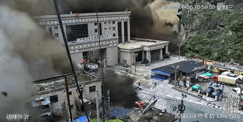
Rasuwagadhi is where Nepal’s road reaches China: the customs post, the yards, and the buildings on either side. An earlier image shows a working border crossing. The later one shows only mud. That is the spot where 32 police and 15 customs officers were standing when the water hit, and where the five missing Japanese travelers were waiting to drive back to Kathmandu. Regrettably, more than 350 people are now dead, and nearly a thousand are still missing.
Onmanorama also points out:
… Scientists had initially pointed to a glacier burst caused by rapid ice melt as a major factor behind the disaster. The US Geological Survey (USGS), which initially faced reports linking the event to an earthquake, later clarified that it was caused by the “break-off of a glacier”.
The International Centre for Integrated Mountain Development (ICIMOD) also suggested that the event was probably an avalanche involving a mixture of ice and rock. A large mass of ice and rock debris reportedly fell into the Lendi Khola, a tributary of the Bhotekoshi River, causing a sudden surge that carried silt and large boulders downstream.
Nepal’s avalanche also affected Tibet and parts of India too.
The disaster also affected China’s Tibet region, where officials reported three deaths and 265 people missing in Gyirong.
The mudslide struck the Gyirong border port, damaging roads, communications and power connections. China deployed drones to assess the damage and prepared aircraft and helicopters for rescue operations.
The flooding also prompted alerts in northern India, where authorities evacuated thousands of people in Bihar as rivers flowing from the Himalayas rose. People had been evacuated from six districts, with plans to move as many as 10,000 to 12,000 people from areas at risk.
However, as one blogger reveals, floods regularly occur in Nepal and there’s no indication that they’re increasing.
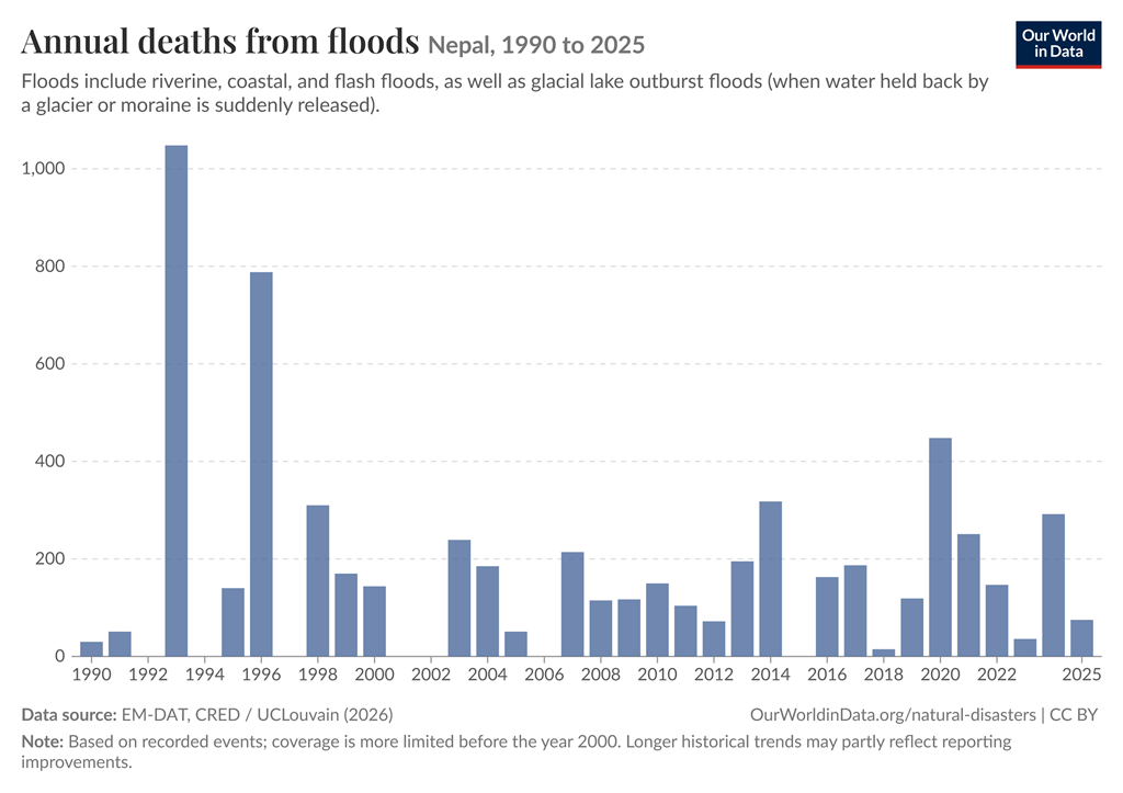
No matter what occurs on the planet, climate-cultists will keep pointing to CO2 as the cause. That narrative is how they extract money. Hundreds of trillions have already been spent, yet the world still runs on fossil fuels for the vast majority of its energy and is likely to keep doing so.
The Himalayas have again shown how beautiful and lethal that region can be. Hopefully, the death toll stays limited and the area recovers soon.
If you’d like to donate to relief efforts in Nepal, a list of nonprofits you can contribute to is here.
PHOTO CREDIT: Flood hitting the Gyirong Port crossing on the China–Nepal border – By Unknown author – https://x.com/resoundnews/status/2092542957060841592, Public Domain, https://commons.wikimedia.org/w/index.php?curid=198252428

